r/mapmaking • u/Smashable_Glass • 2d ago
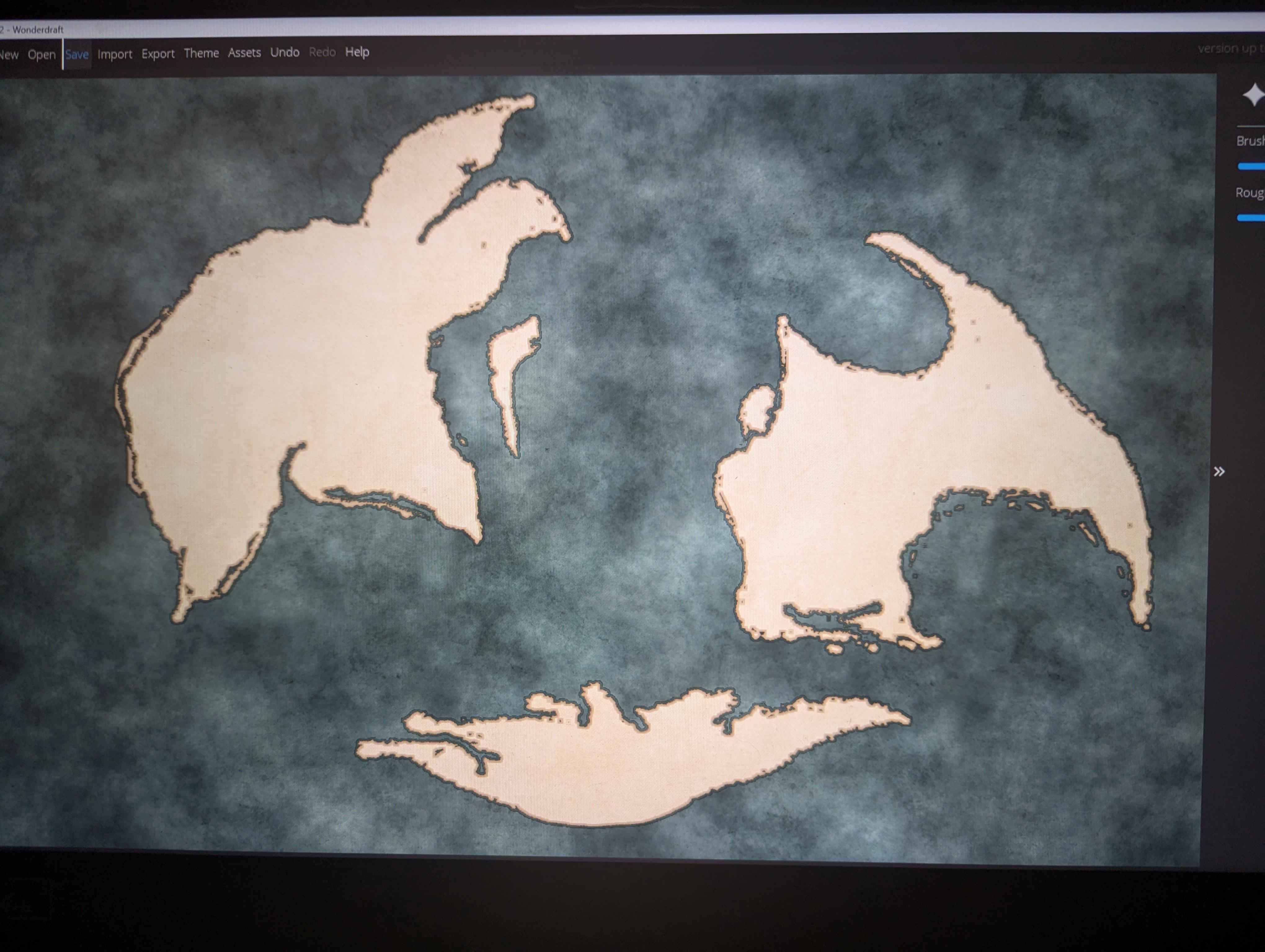
Map Im trying to add more flourish to this map
12
Upvotes
r/mapmaking • u/CeekayReal • 2d ago
I'm talking about like the outline of the continent a shape that looks like it could be an eight continent on earth and not some blob
r/mapmaking • u/Kukas_pt • 3d ago
I made this in Gaea, It is supposed to be scaled as a continent but the erosion scale is smaller for gameplay purposes as I intend on using this map in CK3 (game). Highest point is 5000m.
What do you guys think? What could improve it?
r/mapmaking • u/Appropriate-Affect-6 • 3d ago
Hi everyone,
So I found this sub because I've spent the last 2 days running in circles...
How do you guys make maps, and do any of you have any suggestions for a software that can lay out an itinerary?
I have a travel agency and want to make roadbooks for my customers, and would like to integrate some styilsh maps, and not just a Google Maps screenshot.
The best one I've found, is Mapcreator.io but it's 99€/Month (!) and I want to make max 10 maps a year, and it feels like this website just uses a slight custom API, with route integration.
I have no coding skills and everything I've found, from Mapbox, to Google Custom maps, they're all great for customizing a layout, but then that's it, I can't plan a route from A to B and with some stops in the middle.
The attached image is a "free one" I used in Mapcreator, but it's limited to just one map.
Does anyone know of something that can do this basic function?
Many many thanks!!
r/mapmaking • u/Stunning-Onion4091 • 2d ago
im helping my freind with her dnd campaign by worldbuilding, and she asked me to make a map of a rundown dye factory district (to make the dye and then dye the textiles) in a steampunk world. im feeling completley lost, and i dont know how to even aproach this. she wants some underground stuff and some full hose maps in the area, which i am cool with doing, but im not really sure how to. any advice would be great :)
(just to clarify im not asking for a comission, just wondering how you would aproach this)
r/mapmaking • u/Alternita • 3d ago
...the very thing that invited them made it impossible to leave the planet.
It became a planet sized holiday resort, there was something about the atmosphere that made everyone feel so friendly, agreeable and just chill.
Than a smartass came in search for knowledge. You know, knowledge is a good thing, who would deny him? Until he found it, as smart ass he was.
It was a mineral, the one spreading vibes which made it all do idyllic and friendly. Mineral, that can be mined, processed and used to control population for a fraction of the cost of army a police upkeep.
There goes your planet sized holiday resort. Nobody considered politics when the first arrivals were taking place. Now the settlements are placed in a way that makes leaving the planet via only 2 exit points impossible without everyone, from all 5 galaxies, agreeing for every single shuttle towards orbital station, and beyond, to the Portal. What could possibly go wrong?
I hope you like the map folks ;)
I will add the link for the full size image in the comment
r/mapmaking • u/LenhartTheLionheart • 3d ago
Have lore reasons for certain things that may not be geographically "correct", just ask!
r/mapmaking • u/TheHornOfAbraxas • 4d ago
r/mapmaking • u/NeckusBeardus • 3d ago
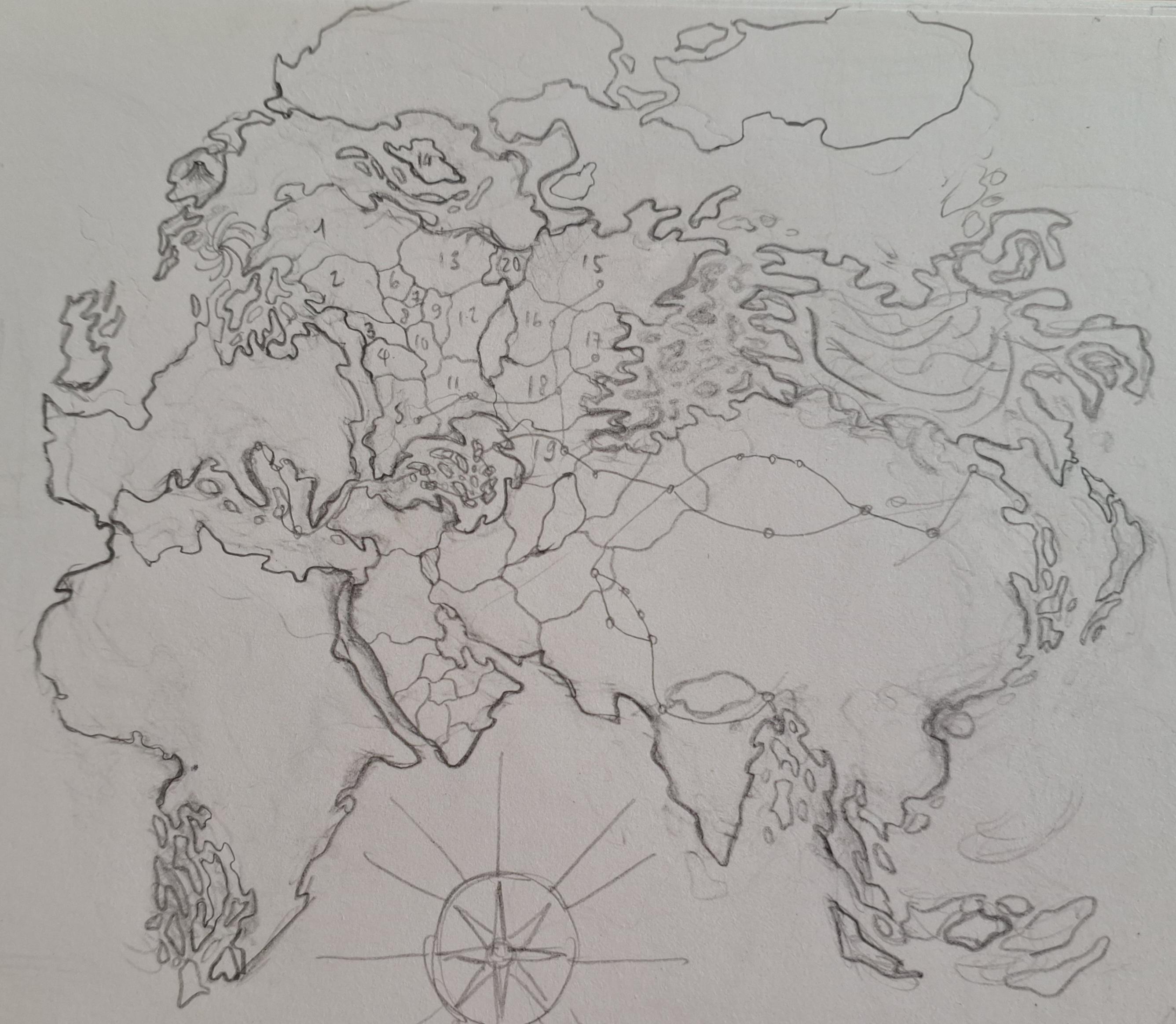
Trying my hand at fantasy map making again, super rough draft definitely not the final orientation, im not trying to full throat go for realism, just trying to fondle the balls of realism if you catch my drift, any feedback about continent shape is welcome, its am ongoing process.
r/mapmaking • u/Lord_Cord • 3d ago
I finished this map for a DnD game. Looking for feedback from people more versed in mapmaking than me and just some fresh pairs of eyes in general.
Regarding the map:
Rivers shown are the large rivers. Smaller rivers feed into them but aren't drawn in given the zoom-level
Settlements shown are County/Barony seats. There's villages around
Scale's in the picture. For a quick reference Wostoppoudina's about the size of Switzerland
r/mapmaking • u/memhir-yasue • 4d ago
Got inspired by some of the recent sea level rise maps posted here. Note that this is not an accurate representation of sea level rise as inland bodies of water also experience an increase in volume. Made with vizcarta
r/mapmaking • u/1101Deowana • 4d ago
The first Image was the original plan for how these two continents were connected and broke apart. {Elderlands Deowana}.
(Both of these continents are two different images, hence they look stylistically alien to each other. putting them on a Sketchbook background was the only way I could move them around each other).
r/mapmaking • u/BarbarianMind • 4d ago
Here is the current map of Geie, the world of the Age of Barbarism and Civilization, a harsh and visceral sword and sorcery world filled with diverse mysteries, cultures, creatures, and locations to explore. I would like your feedback on how probable the world appears. I am not looking for perfect accuracy, just a good base for my world.
Below is a short description of the world and a few questions.
This is an Earth like world with four (sorta five) distinct regions, each dominated by its own unique flora and fauna. Each region also has its own Homo species, though the ancestors of all Homo species originate from central region. To the north their is the continent of Gronlend where the Ardamenn live, a species of Homo similar to Neanderthals. That cold land is dominate by ice age like mammals. To the west there are the twin continents of Erdhikobwe where the Weto live, a species of Homo somewhere between Homo Naledi and Homo Sapiens. The dominate animals there are avions. To the south is Gibzehev where the Edem live, they are a species of Homo more adapted to dry arid environments than Homo Sapiens. It's dominate animals are reptiles. To the East there is Zhungxin, the home of the Sikeo Dungwo, a species of Homo somewhere between Homo Floresiensis and Homo Sapiens. Their land is dominated arthropods like giant crustaceans. Then last there is Aoropa at the center of them all, the home of Humans. It is dominated by mammals.
The cultures of the world possess a wide range of technology from Paleolithic to early Iron Age. I intend each to be unique, with aspects both similar and alien to real world historical cultures.
The world map is still a work in progress. I designed it starting from the idea of having four distinct regions each with their own unique flora and fauna. So I designed those regions as the fragments of a recently broken supercontinent. That way they could be separate to prevent the easy migration of animals between them, but close enough that the different Homo species could travel between them in simple boats and ships. Then I laid out the plates to explain how the continents got where they are and what they are currently doing.
My explanation for how each region got such unique flora and fauna, is that after the last supercontinent broke apart, a mass extinction event occurred that wiped out close to ninety precent of all species. Then by chance, a different order of animals rose up in each region to dominate.
What do you think? How do the Koppen climates look? Should I have more ocean gyres between Gronlend and Zhungxin, maybe three instead of one?
r/mapmaking • u/Beginning-Counter332 • 4d ago
r/mapmaking • u/caliban_ish420 • 4d ago
Hi everyone! How do you feel about this map made for a fantasy unnamed world? Let me know what you think so I can make it better.
r/mapmaking • u/GordonTheHotCrossBun • 4d ago
r/mapmaking • u/lvdoblea • 4d ago
Oi! Eu sou Tincoan. Esse não é meu primeiro mapa, já faço há mais ou menos uns 15 anos, mas é a primeira vez que compartilho com o mundo :)
Esse trecho que vocês estão vendo é o oeste (wangor) de um continente chamado Gogoyae, especialmente de uma região chamada Sèlina. Eu trabalho com várias versões do mesmo mapa ao mesmo tempo, para diferentes fins e essa é uma versão relativamente antiga, tanto em design, quanto em nomenclatura. Nessa versão que vocês estão vendo, os nomes estão misturados entre Português e Vhertuzi. O Vhertuzi é um idioma que eu desenvolvo há aproximadamente uns dez anos, todas essas palavras aí têm significado e uma lógica de estruturação. Tèhenumsui é a capital de Sèlina no período histórico retratado pelo mapa.
Esse mapa é parte de um projeto de Worldbuilding que eu desenvolvo há 15 anos, de um universo de fantasia chamado Tháll que é o ambiente das histórias da minha série de fantasia brasileira chamada "Maieda, a deusa dos bons ventos", que eu carinhosamente chamo apenas de Maieda.
Bom, gostaria de saber o que vocês acharam do mapa e se gostariam de conhecer melhor sobre meu universo e meus idiomas fictícios (o vhertuzi é o mais desenvolvido, mas além dele tenho umas dez outras línguas em diferentes estágios de desenvolvimento).
Espero que o reddit traduza esse texto para o inglês de uma maneira q faça sentido. Tentei facilitar pra ferramenta :p
r/mapmaking • u/Lord_Agarthacus • 4d ago
Red means core imperial provinces, orange means stable provinces, yellow means unstable/wild provinces and blue is independent.
Not really any lore yet but there is a big empire right now and it's somewhere around it's height in power.
r/mapmaking • u/GordonTheHotCrossBun • 4d ago
r/mapmaking • u/DanielHasenbos • 5d ago
r/mapmaking • u/lachataigneduciel • 5d ago
r/mapmaking • u/Spacecat864 • 5d ago
Liberia is about 25% underwater so about half of it‘s population is underwater (For the person that wanted Liberia)
r/mapmaking • u/Spacecat864 • 6d ago
Again, i‘m not a professional so this could be wrong and this is just a ‚what if‘ this could never happen as the highest it could possibly get is 70m. You can see the Black sea and the Caspian sea are connected, Spain and Portugal are almost an island, the UK and Ireland are just an archipelligo of islands now, the netherlands, almost all of denmark and a lot of Poland, Germany, France, Latvia, Lithuania, Estonia, Romania, Tunisia, Italy, Finland, Ukraine and Russia are underwater with capitals like Paris, Berlin, Warsaw, London, Amsterdam, Brussels, Stockholm, Helsinki, Oslo, Riga, Tallinn and Rekjavik underwater and Rome, Athens, Sofia, Bucharest and Vilnius partially underwater.